GO DEEPER…the upcoming 10-14 days
Your LATEST IN-DEPTH VIDEO PRESENTATION of HAWAII’S WAVES & WEATHER by SURF NEWS NETWORK
READ LATEST BIG PICTURE HERE
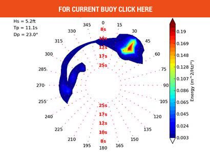
On SNN: spectral graphs are helpful when the text output doesn’t yet show the slivers of super long periods as early. https://www.surfnewsnetwork.com/buoy/spectra-snapshots/ or GO HERE
SNN: spectral graphs are helpful when the text output doesn’t yet show the slivers of super long periods as early. https://www.surfnewsnetwork.com/buoy/spectra-snapshots/ or GO HERE
Surf Climatology HERE
NWS criteria for High Surf Advisories (first number) & Warnings (second number).
All surf height observations & forecasts are for full ‘face’ surf height, or ‘trough to the crest’ of the wave.
North-Facing Shores 15 Feet and 25 Feet
West-Facing Shores – Remaining Islands 12 Feet and 20 Feet
West-Facing Shores – Big Island 8 Feet and 12 Feet
South-Facing Shores 8 Feet and 15 Feet
East-Facing Shores 8 Feet and 15 Feet
Get the latest Central Pac Hawaii HERE
Terms: Eg. The split Jetstream is why all the Gulf and Alaskan storms are sending North swells. There’s that strong, persistent blocking ridge west of the dateline bumped the Jet up and over into the Bering Sea most November.
Note: The spectral density graph in the SNN Buoy Page (link below) shows slivers of forerunners that initial text readings do not ‘show’ till later on written buoy updates. Also, note the vertical graph is not ‘wave height’ rather its a measure of wave energy in hertz (frequency or cycles/sec) for the whole ‘band’ (the distribution of power/period in the total wave energy field/spectrum).
For SNN’s Buoys ‘per shore’ arrangement pls GO HERE
Links: Get the latest on the tropics at www.hurricanes.gov
For more on the Westpac Typhoons GO HERE
The Central Pacific Hurricane Center outlook for the 2017 Central Pacific Hurricane Season calls for 5 to 8 tropical cyclones to either develop or cross into the Central Pacific with a 40% chance for an above-normal season, a 40% chance for a normal season, and a 20% chance for a below-normal season. An average season has 4 to 5 tropical cyclones, which include tropical depressions, tropical storms, and hurricanes.
Tropical depression forms when a low-pressure area is accompanied by thunderstorms that produce a circular wind flow with maximum sustained winds below 39 mph. An upgrade to a tropical storm occurs when cyclonic circulation becomes more organized and maximum sustained winds gust between 39 mph and 73 mph. A tropical storm is then upgraded to Category 1 hurricane status as maximum sustained winds increase to between 74 mph and 95 mph. (The highest classification in the scale, Category 5, is reserved for storms with winds exceeding 156 mph).
Tropical cyclones go by many names around the world, and the terminology can get confusing. Once a tropical cyclone strengthens to the point where it has gale-force winds—39 mph or greater—it becomes a tropical storm. A storm that reaches tropical storm strength usually gets its own name to help us quickly identify it in forecasts and warnings. Once a tropical storm begins producing sustained winds of around 75 mph, we call the storm a typhoon in the western Pacific near Asia and a hurricane in the oceans on either side of North America. A “typhoon” and a “hurricane” are the same kind of storm, they just go by different names…it’s only a matter of geography.
Shoaling is the effect by which surface waves entering shallower water change in wave height (or grow) due to speed change (or slow down). Wavelength is reduced when going from deeper to shallower. The ‘energy flux’ must remain constant (nature’s liquid law) so the reduction in wave group (transport) speed is compensated by an increase in wave height (and thus wave energy density). Yeah, I know…waves are complex AND amazing.
Refraction is the change in direction of waves that occurs when waves travel from one medium to another or depth change. Refraction is always accompanied by a wavelength & speed change. Diffraction is the bending & spreading of waves around obstacles (‘reefs’ and openings).
High Surf Advisories & Warnings NWS criteria below in coordination with Hawai’i civil defense agencies & water safety organizations.
All surf height observations & forecasts are for the full face surf height, from the trough to the crest of the wave.
| Location | Advisory | Warning |
|---|---|---|
| North-Facing Shores | 15 Feet | 25 Feet |
| West-Facing Shores – Big Island | 8 Feet | 12 Feet |
| West-Facing Shores – Remaining Islands | 12 Feet | 20 Feet |
| South-Facing Shores | 8 Feet | 15 Feet |
| East-Facing Shores | 8 Feet | 15 Feet |
‘Travel Time’ Buoy 51101 to Waimea Buoy
Distance: 269 nautical miles (~310 miles)
Angle: 307 deg
Wave Wave Wave Depth Wave Direction (deg)———-
Period Length Speed Shallow 295, 305, 315, 325, 335, 345, 355
(s) (ft) (nm/h) (ft) Travel Time (hours)———-
10sec. 512. 15. 256. 17.3, 17.7, 17.6, 16.9, 15.7, 14.0, 11.9
12sec. 737. 18. 369. 14.5, 14.8, 14.6, 14.0, 13.0, 11.6, 9.9
14sec. 1003. 21. 502. 12.4, 12.7, 12.5, 12.0, 11.2, 10.0, 8.5
16sec. 1310. 24. 655. 10.8, ,1 1.1, 11.0, 10.5, 9.8, 8.7, 7.4
18sec. 1658. 27. 829. 9.6, 9.8, 9.8, 9.4, 8.7, 7.8, 6.6
20sec. 2047. 30. 1024. 8.7 8.9 8.8 8.4 7.8 7.0 5.9
22sec. 2477. 33. 1239. 7.9 8.1 8.0 7.7 7.1 6.3 5.4
24sec. 2948. 36. 1474. 7.2 7.4 7.3 7.0 6.5 5.8 4.9
Tropical Storm – winds 39-73 mph (34-63 kt)
Category 1 – winds 74-95 mph (64-82 kt)
Category 2 – winds 96-110 mph (83-95 kt)
Category 3 – winds 111-130 mph (96-113 kt)
Category 4 – winds 131-155 mph (114-135 kt)
Category 5 – winds 156 mph and up (135+ kt)
Please visit the Central Pacific Hurricane Center website at www.weather.gov/cphc for the most recent bulletins.
ENSO (The El Niño-Southern Oscillation) is a single naturally occurring climate phenomenon in three states or phases. These involve fluctuating ocean temperatures in the equatorial Pacific. … When temperatures in the ENSO region of the Pacific are near average it is known as ENSO ‘neutral’, meaning that the oscillation is neither in a warm or cool phase.The two opposite phases, “El Niño”(warmer than average) and “La Niña”(cooler than average) require certain changes in both the ocean and the atmosphere because ENSO is a coupled climate phenomenon. “Neutral” is in the middle of the continuum. The MJO (Madden-Julian Oscillation) is an eastward moving disturbance of clouds, rainfall, winds, and pressure that traverse the planet in the tropics and returns to its initial starting point in 30 to 60 days, on average, unlike ENSO which is stationary. In a nutshell, a more active ENSO means more surf.


